Clagstone Country EstatesContact

Site data

Every number we can
stand behind, in one place.

If you are pricing a block, sizing a service, or just checking our arithmetic, start here instead of asking us to dig it out. Every figure below traces to the approved construction plans or to the geometry files you can download at the bottom of the page. Where a number is still soft, it says so.

Olson Engineering job 23081. Approved by Lakes Highway District on February 3, 2026, no exceptions taken.
Homesites
58
lots
Platted in lots
356.172
acres
New public road
6,503
feet
Water main
5,478
feet
Fire hydrants
5
assemblies
Culverts
7
18 in CMP

The lot schedule

All 58 homesites, with acreage as it appears on Sheet C-4. 49 of them are six acres or better. 9 come in under six, most by hundredths, which is why the rest of the site says six acres give or take rather than pretending they are all identical.

Download as CSV
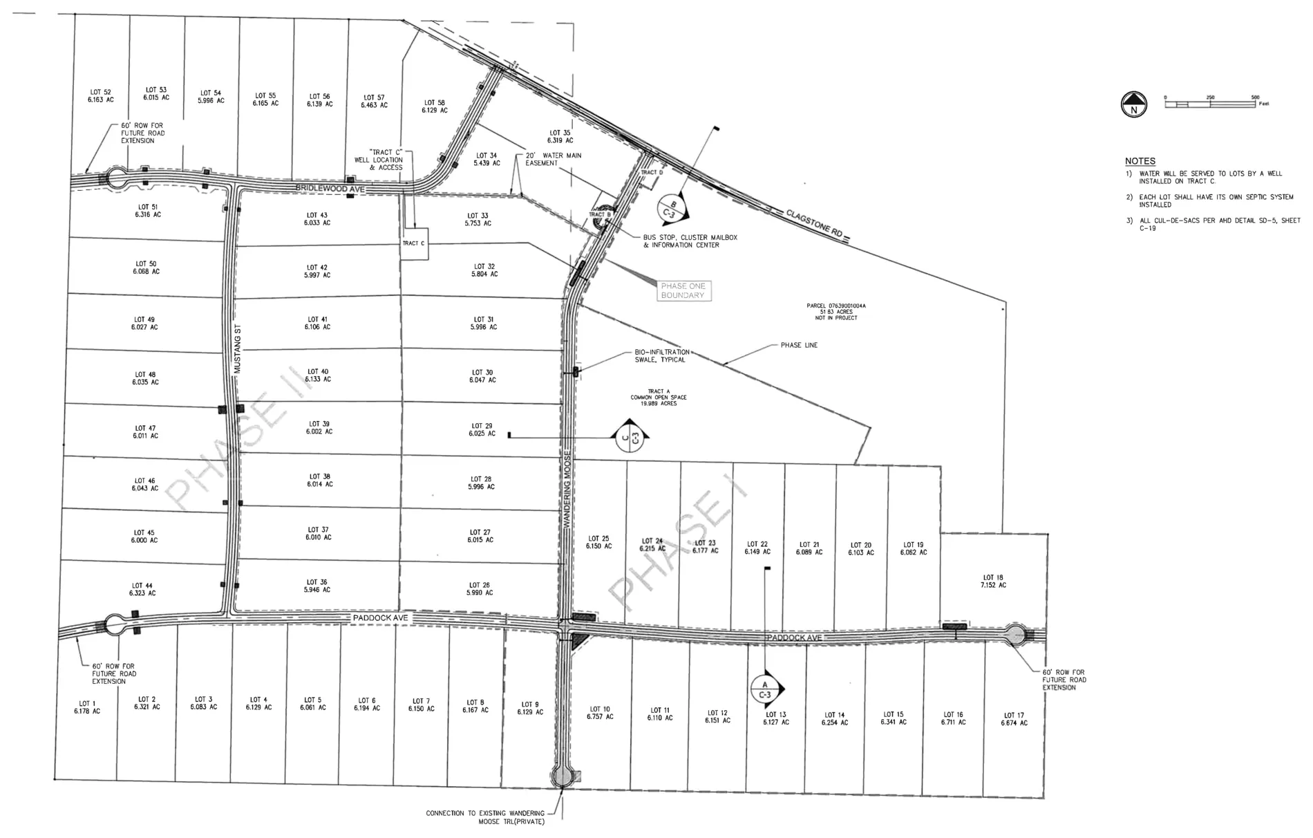
The overall site layout from the approved plans, showing all fifty-eight numbered lots with their acreages, the four streets, and the phase line. Bridlewood Avenue runs along the north and meets Mustang Street at a cul-de-sac on the west, Paddock Avenue runs along the south to a cul-de-sac of its own, and Wandering Moose Road runs north to south through the middle, meeting North Clagstone Road at the top right and the existing private Wandering Moose Trail at the bottom. Tract A is the common open space east of Wandering Moose, Tract B carries the bus stop and cluster mailboxes at the entrance, Tract C is the well location, and bio-infiltration swales are marked along the roads.
The overall site layout, Sheet C-4. Every acreage in the table below is read off this drawing. Worth noticing: the phase line running through the middle, the three sixty foot rights of way stubbed to the boundary for future roads, and the swales drawn along the streets. Drawing by Olson Engineering, job 23081, cropped to the plan. The stamped sheet governs.
Paddock Ave25 lots · 156.654 ac
LotAcresBlockPhaseWater
16.1832Community
26.3232Community
36.0832Community
46.1332Community
56.0632Community
66.1932Community
76.1532Community
86.1732Community
96.1331Community
106.7621Community
116.1121Community
126.1521Community
136.1321Community
146.2521Community
156.3421Community
166.7121Community
176.6721Community
187.1521Community
196.0821Community
206.1021Community
216.0921Community
226.1521Community
236.1821Community
246.2121Community
256.1521Community
Wandering Moose Rd10 lots · 59.384 ac
LotAcresBlockPhaseWater
265.99031Community
276.0111Community
285.99611Community
296.0311Community
306.0511Community
315.99611Community
325.80431Community
335.75331Community
345.43932Community
356.3242Community
Mustang St16 lots · 97.064 ac
LotAcresBlockPhaseWater
365.94632Community
376.0112Community
386.0112Community
396.0012Community
406.1312Community
416.1112Community
425.99712Community
436.0332Community
446.3242Community
456.0032Community
466.0442Community
476.0132Community
486.0432Community
496.0332Community
506.0742Community
516.3232Community
Bridlewood Ave7 lots · 43.070 ac
LotAcresBlockPhaseWater
526.1632Community
536.0132Community
545.99632Community
556.1732Community
566.1432Community
576.4652Community
586.1352Community
All 58 lots356.172 acres · smallest 5.439 (Lot 34) · largest 7.152 (Lot 18) · Phase 1 is 25 lots

Acreage per Sheet C-4. Lot polygons on the map are drawn to the site plan and are close, not surveyed. Corner pins and the recorded legal description govern, and they will differ from these polygons by a few feet in places.

Streets

Four named streets inside the neighborhood, all public and all plowed by the highway district. Wandering Moose Road picks up the name of the old private trail it connects to at the south end.

Bridlewood Ave
7 lots
Mustang St
16 lots
Paddock Ave
25 lots
Wandering Moose Rd
10 lots

Three sixty-foot rights of way stub to the boundary and stay reserved for future connection. If you are buying next to one, that is a road easement, not a side yard.

Tracts

Ground held in common rather than sold as homesites.

Tract A, open space
19.989 acres. Common ground, held for everybody.
Tract B, entrance
0.30 acres. School bus turnout, cluster mailboxes, information kiosk.
Tract C, well site
0.6 acres. The community well and its access.

What is going in the ground

Four systems, one trench season. The three buried utilities wear the color a locator would paint them: red for electric, blue for water, orange for communications. Roads get gray, because a road is not something anyone has to go looking for.

Roads

New public road
6,503 ft
Wandering Moose Rd
3,652 ft
Paddock Ave
2,851 ft
Pavement width
28 ft
Right of way
60 ft
Crown
2 percent
Section
2 in / 4 in / 12 in
Cul-de-sac radius
60 ft
Entrance turn lane
210 ft decel, 80 ft storage

Built to ISPWC and Lakes Highway District standards, then accepted by the district for maintenance. Nobody bills you for plowing.

Water

Main, total
5,478 ft
Pipe
6 in PVC
Minimum bury
5 ft
Easement
20 ft
Fire hydrants
5, per SD-404
Service to each lot
1 in, per SD-401
Testing
ISPWC
Wastewater
Septic, per lot

The approved set covers the distribution system. The well site on Tract C is built under a separate permit. Detail on the water page.

Power

Provider
Northern Lights Inc.
Service
Three phase
Distribution
Underground, in conduit
At each frontage
Conduit stub and marker
Substation
Athol
Well pump service
600 A, three phase

A new recloser goes in at North Clagstone Road. Detail on the power page.

Communications

Operator
CIS, neighborhood owned
Trunk ring
About 2 miles, planned
Cable
72 fiber, single mode, per phase
Topology
Ring, diverse return
At each lot line
Vault
Handoff
Single mode fiber, standard SFP
Addressing
IPv6 per parcel, IPv4 supported

These are the only figures on this page that are not from the approved plans. Olson designed the roads and the water system. There is no communications conduit anywhere in that set, so CIS is our own design and the ring length is our own routing, not an engineered alignment. Bring whatever equipment you like. Detail on the design pages.

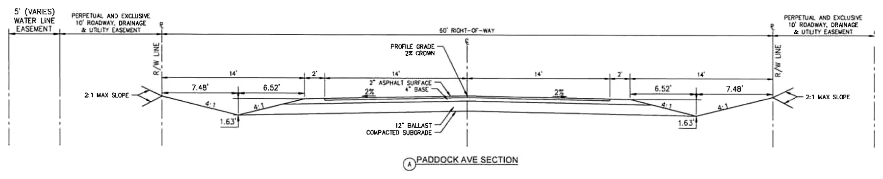
Typical road section from the approved plans, drawn across Paddock Avenue. It dimensions a sixty foot right of way with fourteen feet of pavement each side of the centerline, a two percent crown, two inches of asphalt surface over four inches of base over twelve inches of ballast on compacted subgrade, side slopes at two to one maximum, a perpetual and exclusive ten foot roadway, drainage and utility easement outside the right of way on both sides, and a five foot water line easement beyond that.
The typical section, Sheet C-3. This one drawing carries most of the road and easement numbers on this page: the sixty foot right of way, the twenty eight feet of pavement, the two percent crown, the layer cake underneath it, and the ten foot utility easement on each side that the power and the fiber live in. Drawing by Olson Engineering, job 23081, cropped to the section. The stamped sheet governs.

Where the water goes

There is no storm sewer out here and there does not need to be. Runoff leaves the pavement, crosses a graded shoulder into a swale, and either soaks away or moves through a culvert to the next low spot. It is the oldest drainage idea there is and on ground this porous it works.

Five swale basins are drawn along the two streets, each a foot deep with three-to-one side slopes, and drywells take the water down where a basin alone will not clear it. Seven culverts carry it under the road. Cut and fill slopes are held to two-to-one, and the plans work to one-foot contours, which is a finer grain than the ground really has.

The profiles also answer a question people ask on the first visit. The road runs between about 2,490 and 2,509 feet of elevation, so the ground sits right around twenty-five hundred feet.

Culverts
7, all 18 in CMP
Culvert pipe, total
397 ft
Cover over culverts
12 in minimum
Swale basins
5
Swale depth
1 ft, 3:1 slopes
Drywells
Single depth, per detail
Cut and fill slopes
2:1 maximum
Contour interval
1 ft
Road elevation
2,490 to 2,509 ft
Cul-de-sacs
2

Read off the road plan and profile sheets, C-6 through C-11. Each lot carries its own septic system, which is stated on every one of them.

Building envelopes

57 envelopes are drawn and surveyed on the plans, ranging from 8,055 to 13,008 square feet of buildable area. On a six acre lot that is a generous footprint with room left for outbuildings, but it is a defined footprint, and it is where the house goes.

You can turn the envelopes on over the lots on the plat map.

Easements

Worth knowing before you site a shop or a fence.

Ten feet each side of the right of way
Perpetual roadway, drainage and utility easement. This is where the fiber trunk and the power run.
Twenty feet on the water main
Keep it clear for the district and for repairs.
Sixty foot future road stubs
Three of them, reserved at the boundary.

Take the geometry with you

Open these in QGIS, Civil 3D, or anything that reads GeoJSON. Coordinates are WGS84, reprojected from Idaho State Plane West.

Agents: these are the files to send a client before the drive. More on what to do with them is on the page for cooperating brokers.

The stamped plan set itself is not posted here. It is Olson Engineering's sealed work, and a copy comes from Joe or from the district. Ask and it is yours.

What this page is, and what it is not

What is approved is a construction plan set. A district engineer read it, stamped it on February 3, 2026, and took no exceptions. That is engineering approval to build the roads and the water system as drawn. It is not a recorded plat, and nothing here creates a legal lot description.

Use these numbers to budget, to size a service, and to decide whether to come walk it. Do not use them to set a stake. The lot polygons in the download are drawn to the site plan rather than surveyed, and the recorded plat and your corner pins govern when they disagree.

Some of it is still moving. Phase 2 lots are shown because they are planned, not because they are for sale today, and a few figures will tighten as the survey base files come across from Olson. When they do, this page changes and the change shows up in the file history rather than quietly.