Clagstone Country EstatesContact

The Land

Fifty-eight parcels.
One quiet piece of country.

You don't own land in North Idaho. You look after it for a while. That's the honest register for this place, so it's the register we start with.

Three hundred and eighty-two platted acres between the Rathdrum Prairie and the Cabinet foothills, laid out into fifty-eight homesites of six acres, give or take, with twenty acres of shared open space woven through the middle. The plat is PE-stamped by Olson Engineering. The roads are public and paved. Everything you'll read on this page is on file.

Walk it once and the pitch reads itself. The larch turns in October. Elk drift the low fields at dusk. The Bunco trail system is ten miles up the road. And when the storm comes through in January, somebody else's plow beats you to the pavement.

The interactive plat

Tap any homesite for acreage, orientation and the walking notes. Switch to satellite to see the timber on the ground, show the surveyed building areas, or look five miles down the road at Athol. The expand control opens it full screen.

Download the lot mapTwo pages, the whole plat and every acreage. Print it, or send it on.

Each homesite is drawn to its approved acreage, so the sizes are true to one another. The outlines themselves are approximate: the surveyed lot boundaries live with Olson Engineering and are not published yet, so treat this as a map of where each homesite sits, not a survey of where its corners fall. Numbers on this page come off Sheet C-4 of the Olson Engineering plan set (job 23081), approved by Lakes Highway District, February 2026. The stamped plan set and the table below govern.

Plat by the numbers

Homesites
58
Total platted acres
356.17
Average parcel
6.14 ac
Under six acres
9

Another 19.989 acres of shared open space sit alongside the 58 homesites as Tract A on the approved plans, held in common by the association and written into the covenants to stay that way.

Shaded relief map of the country Clagstone sits in, the ground between the Rathdrum Prairie and the Cabinet foothills

What you're buying

The physical, without decoration.

58
Legacy homesites
6 ac
Give or take
382
Platted acres
20
Acres shared open space

Homesites run six acres, give or take. Most of the fifty-eight come in over six; nine come in a hair under on the approved plans, and the three shortest, 32, 33, and 34, are priced accordingly. Every parcel is sited to hold a home without crowding a neighbor, with south-facing building envelopes and protected water frontage where the land allows. Every figure, homesite by homesite, is on the interactive plat.

The construction plans are engineered by Olson Engineering and approved by Lakes Highway District, no exceptions taken, February 2026. Twenty acres of shared open space stitch the neighborhood together and hold the ridge lines open. The developer lives nearby. You take responsibility for a piece of country and you pass it on better than you found it.

Where it sits

In the quiet middle of the Golden Triangle.

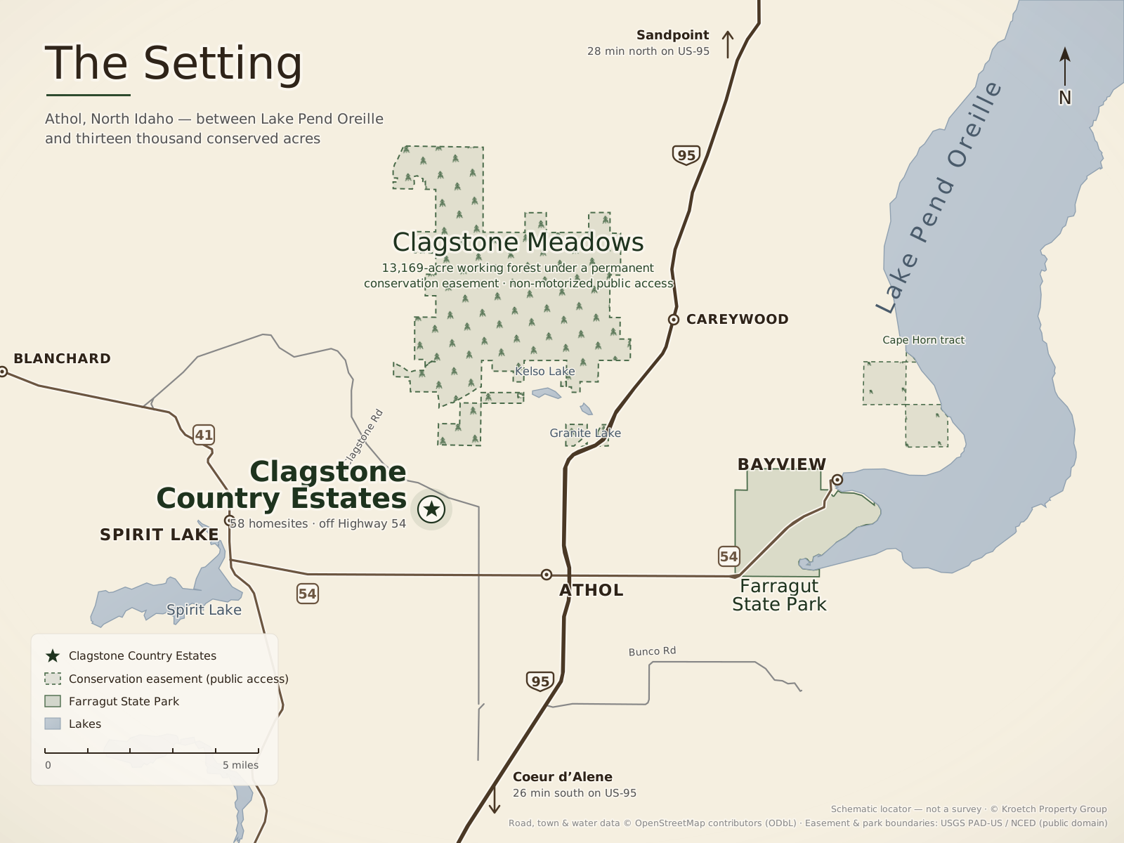
Draw a line from Sandpoint down to Coeur d'Alene, then over through Spirit Lake and Pend Oreille and back up past Farragut, and Clagstone sits in the middle of what falls inside it. Close enough that a town errand doesn't take a day. Far enough that the loudest thing outside is weather.

Every figure comes from the location table on file. When you hear other numbers in the corridor, drive them yourself. Ours hold up.

Ground-level view along the public paved road that runs through Clagstone Country Estates, timber on either side and a clear Idaho sky above

The roads

Paved to your front door.
Plowed by somebody else.

The roads through Clagstone are public. Built to standard, dedicated, and plowed by Lakes Highway District every storm at no cost to you.

They have names now, on the approved plans: Bridlewood Avenue along the north, Mustang Street down the west, Wandering Moose Road through the middle, picking up the old private Wandering Moose Trail where the neighborhood meets it, and Paddock Avenue across the south. Three sixty-foot rights-of-way are already reserved at the edges, so the county grid can grow someday without touching your lot line.

Built to standard means something specific here. Each interior street is twenty-eight feet of pavement inside a sixty-foot right of way, crowned two percent to shed water, over four inches of base and a foot of ballast. The cul-de-sacs turn on a hundred-and-twenty-foot circle, which is the radius a fire truck needs. Out at the county road, the plans add a left turn lane into the neighborhood, two hundred ten feet of deceleration and eighty feet of storage between long tapers, so slowing down to turn home is not an event.

No road association. No maintenance agreement for your lender to ask about. No plow bill in January. Pavement from the tarmac at Spokane International all the way to your own driveway.

It is a quieter kind of security than a keypad at the entrance, and a more useful one at five in the morning in February.

The rest of the trench

The road is the part you can see.

Two more systems go in while the ground is open, and both of them answer questions rural buyers are used to being told to solve themselves.

Water you do not have to drill for.

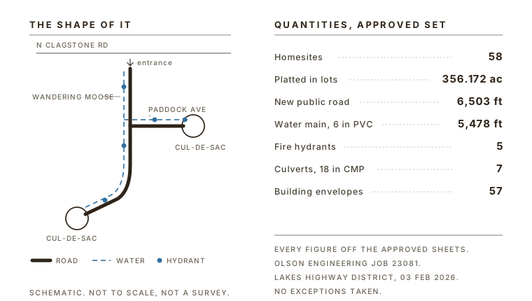
A community system, not fifty-eight private wells and fifty-eight separate gambles on depth and quality. Five thousand four hundred seventy-eight feet of six inch main, buried five feet down, five fire hydrants on the line, and a service stub waiting at your lot.

How the water works

Three phase, and none of it on poles.

Northern Lights brings three phase power underground in conduit along the roads, with a stub and a marker at every frontage. It runs a welder in the shop as easily as it runs the house, and there is no line of poles across the view to pay for it.

How the power works

The public land, honestly

Up Bunco Road, the country opens up.

You will hear people say a place like this has National Forest at the back fence. It rarely does, and this one does not. What it has is ten miles up the road: the Bunco trail system, which reaches into the Idaho Panhandle National Forests and the ridges around Bernard Peak and the powerline network beyond.

The road in passes Stimson timberland before it reaches Forest Service ground. The trailhead itself sits on the Idaho Panhandle National Forests, and Kootenai County grooms sixty miles of winter routes out of that lot. Naming who owns what is the honest thing.

Then there's the ground that shares our name. Clagstone Meadows, the thirteen-thousand-acre Stimson timber tract next door, was approved for two golf courses and twelve hundred homes back in 2010. Stimson chose otherwise. The state and the Trust for Public Land bought a permanent conservation easement, the land stays working timber forever, and since 2017 most of it has been open to the public to walk: non-motorized, through four signed gates with parking areas, the way local hunters and hikers use it every fall. Timber somebody protected instead of subdivided, and your grandkids can legally walk it.

What you get is sixty miles of groomed winter routes, elk country in the shoulders of the season, and public land big enough that you can go all day without seeing the same person twice. Not at your back fence. Close enough to walk out the door toward.

Schematic locator map of the Clagstone Country Estates setting: the development star west of US-95 off Highway 54 near Athol, the 13,169-acre Clagstone Meadows conservation easement to the north, Farragut State Park and Bayview to the east, and Lake Pend Oreille beyond
The setting, drawn from the record: easement and park boundaries from USGS PAD-US and the National Conservation Easement Database, roads and water © OpenStreetMap contributors (ODbL), site location from the Olson Engineering civil plat. Schematic locator, not a survey.

The shared ground

Common ground, kept country.

Twenty acres, give or take, of shared open space run through the middle of Clagstone, stitching the neighborhood together and holding sightlines open across the ridges. It is not a lawn to be manicured. It is country to be kept country.

The covenants are written for that outcome. Ridge lines stay open. Building envelopes stay south-facing. A Design Review Board is written into the covenants and will take up the work the day it is seated. Until it is, the covenants stand on their own text, which is the way it should be.

None of this is a country club with a badge on the door. It is a neighborhood built to hold up under the weather and the calendar, and to still look like North Idaho when your grandchildren are the ones walking it.

Show your work

We would rather you checked than took our word for it.

Everything on this page traces back to a stamped drawing, and the drawings are not a secret. Here is the short tally. The long one, with all fifty-eight lot acreages, the easement widths, the utility specifications and the parcel geometry as a download, is one click away.

Project: Clagstone Country EstatesSubject: quantities takeoffSource: approved plans, job 23081
Quantities takeoff on engineering paper. A schematic shows the entrance at North Clagstone Road, Wandering Moose running south to a cul-de-sac, Paddock Avenue running east to another, with the water main alongside and five hydrants marked. The tally beside it reads 58 homesites, 356.172 acres platted in lots, 6,503 feet of new public road, 5,478 feet of six inch water main, five fire hydrants, seven 18 inch culverts, and 57 building envelopes.
The short version of a very long spreadsheet
Open the site data sheet

Lot schedule, specifications, easements, drainage, and the geometry as GeoJSON and CSV.

The parcel table. All fifty-eight, listed.

Numbered in the marketing sequence, with the plat's own Phase and Block references carried in the note.

Status confirmed with the brokerage on August 11, 2026: 58 available. We keep this by hand rather than off a feed, so call to confirm a specific parcel before anyone makes the drive.

LotAcresStatusPlat reference
16.18AvailableAcreage per approved construction plans, Sheet C-4 (Olson Engineering job 23081, approved by Lakes Highway District 02/03/2026).
26.32AvailableAcreage per approved construction plans, Sheet C-4 (Olson Engineering job 23081, approved by Lakes Highway District 02/03/2026).
36.08AvailableAcreage per approved construction plans, Sheet C-4 (Olson Engineering job 23081, approved by Lakes Highway District 02/03/2026).
46.13AvailableAcreage per approved construction plans, Sheet C-4 (Olson Engineering job 23081, approved by Lakes Highway District 02/03/2026).
56.06AvailableAcreage per approved construction plans, Sheet C-4 (Olson Engineering job 23081, approved by Lakes Highway District 02/03/2026).
66.19AvailableAcreage per approved construction plans, Sheet C-4 (Olson Engineering job 23081, approved by Lakes Highway District 02/03/2026).
76.15AvailableAcreage per approved construction plans, Sheet C-4 (Olson Engineering job 23081, approved by Lakes Highway District 02/03/2026).
86.17AvailableAcreage per approved construction plans, Sheet C-4 (Olson Engineering job 23081, approved by Lakes Highway District 02/03/2026).
96.13AvailableAcreage per approved construction plans, Sheet C-4 (Olson Engineering job 23081, approved by Lakes Highway District 02/03/2026).
106.76AvailableAcreage per approved construction plans, Sheet C-4 (Olson Engineering job 23081, approved by Lakes Highway District 02/03/2026).
116.11AvailableAcreage per approved construction plans, Sheet C-4 (Olson Engineering job 23081, approved by Lakes Highway District 02/03/2026).
126.15AvailableAcreage per approved construction plans, Sheet C-4 (Olson Engineering job 23081, approved by Lakes Highway District 02/03/2026).
136.13AvailableAcreage per approved construction plans, Sheet C-4 (Olson Engineering job 23081, approved by Lakes Highway District 02/03/2026).
146.25AvailableAcreage per approved construction plans, Sheet C-4 (Olson Engineering job 23081, approved by Lakes Highway District 02/03/2026).
156.34AvailableAcreage per approved construction plans, Sheet C-4 (Olson Engineering job 23081, approved by Lakes Highway District 02/03/2026).
166.71AvailableAcreage per approved construction plans, Sheet C-4 (Olson Engineering job 23081, approved by Lakes Highway District 02/03/2026).
176.67AvailableAcreage per approved construction plans, Sheet C-4 (Olson Engineering job 23081, approved by Lakes Highway District 02/03/2026).
187.15AvailableAcreage per approved construction plans, Sheet C-4 (Olson Engineering job 23081, approved by Lakes Highway District 02/03/2026).
196.08AvailableAcreage per approved construction plans, Sheet C-4 (Olson Engineering job 23081, approved by Lakes Highway District 02/03/2026).
206.10AvailableAcreage per approved construction plans, Sheet C-4 (Olson Engineering job 23081, approved by Lakes Highway District 02/03/2026).
216.09AvailableAcreage per approved construction plans, Sheet C-4 (Olson Engineering job 23081, approved by Lakes Highway District 02/03/2026).
226.15AvailableAcreage per approved construction plans, Sheet C-4 (Olson Engineering job 23081, approved by Lakes Highway District 02/03/2026).
236.18AvailableAcreage per approved construction plans, Sheet C-4 (Olson Engineering job 23081, approved by Lakes Highway District 02/03/2026).
246.21AvailableAcreage per approved construction plans, Sheet C-4 (Olson Engineering job 23081, approved by Lakes Highway District 02/03/2026).
256.15AvailableAcreage per approved construction plans, Sheet C-4 (Olson Engineering job 23081, approved by Lakes Highway District 02/03/2026).
265.990under sixAvailableAcreage per approved construction plans, Sheet C-4 (Olson Engineering job 23081, approved by Lakes Highway District 02/03/2026).
276.01AvailableAcreage per approved construction plans, Sheet C-4 (Olson Engineering job 23081, approved by Lakes Highway District 02/03/2026).
285.996under sixAvailableAcreage per approved construction plans, Sheet C-4 (Olson Engineering job 23081, approved by Lakes Highway District 02/03/2026).
296.03AvailableAcreage per approved construction plans, Sheet C-4 (Olson Engineering job 23081, approved by Lakes Highway District 02/03/2026).
306.05AvailableAcreage per approved construction plans, Sheet C-4 (Olson Engineering job 23081, approved by Lakes Highway District 02/03/2026).
315.996under sixAvailableAcreage per approved construction plans, Sheet C-4 (Olson Engineering job 23081, approved by Lakes Highway District 02/03/2026).
325.804under sixAvailableSub-six-acre parcel; priced accordingly. Acreage per approved construction plans, Sheet C-4 (Olson Engineering job 23081, approved by Lakes Highway District 02/03/2026).
335.753under sixAvailableSub-six-acre parcel; priced accordingly. Acreage per approved construction plans, Sheet C-4 (Olson Engineering job 23081, approved by Lakes Highway District 02/03/2026).
345.439under sixAvailableSub-six-acre parcel; priced accordingly. Acreage per approved construction plans, Sheet C-4 (Olson Engineering job 23081, approved by Lakes Highway District 02/03/2026).
356.32AvailableAcreage per approved construction plans, Sheet C-4 (Olson Engineering job 23081, approved by Lakes Highway District 02/03/2026).
365.946under sixAvailableAcreage per approved construction plans, Sheet C-4 (Olson Engineering job 23081, approved by Lakes Highway District 02/03/2026).
376.01AvailableAcreage per approved construction plans, Sheet C-4 (Olson Engineering job 23081, approved by Lakes Highway District 02/03/2026).
386.01AvailableAcreage per approved construction plans, Sheet C-4 (Olson Engineering job 23081, approved by Lakes Highway District 02/03/2026).
396.00AvailableAcreage per approved construction plans, Sheet C-4 (Olson Engineering job 23081, approved by Lakes Highway District 02/03/2026).
406.13AvailableAcreage per approved construction plans, Sheet C-4 (Olson Engineering job 23081, approved by Lakes Highway District 02/03/2026).
416.11AvailableAcreage per approved construction plans, Sheet C-4 (Olson Engineering job 23081, approved by Lakes Highway District 02/03/2026).
425.997under sixAvailableAcreage per approved construction plans, Sheet C-4 (Olson Engineering job 23081, approved by Lakes Highway District 02/03/2026).
436.03AvailableAcreage per approved construction plans, Sheet C-4 (Olson Engineering job 23081, approved by Lakes Highway District 02/03/2026).
446.32AvailableAcreage per approved construction plans, Sheet C-4 (Olson Engineering job 23081, approved by Lakes Highway District 02/03/2026).
456.00AvailableAcreage per approved construction plans, Sheet C-4 (Olson Engineering job 23081, approved by Lakes Highway District 02/03/2026).
466.04AvailableAcreage per approved construction plans, Sheet C-4 (Olson Engineering job 23081, approved by Lakes Highway District 02/03/2026).
476.01AvailableAcreage per approved construction plans, Sheet C-4 (Olson Engineering job 23081, approved by Lakes Highway District 02/03/2026).
486.04AvailableAcreage per approved construction plans, Sheet C-4 (Olson Engineering job 23081, approved by Lakes Highway District 02/03/2026).
496.03AvailableAcreage per approved construction plans, Sheet C-4 (Olson Engineering job 23081, approved by Lakes Highway District 02/03/2026).
506.07AvailableAcreage per approved construction plans, Sheet C-4 (Olson Engineering job 23081, approved by Lakes Highway District 02/03/2026).
516.32AvailableAcreage per approved construction plans, Sheet C-4 (Olson Engineering job 23081, approved by Lakes Highway District 02/03/2026).
526.16AvailableAcreage per approved construction plans, Sheet C-4 (Olson Engineering job 23081, approved by Lakes Highway District 02/03/2026).
536.01AvailableAcreage per approved construction plans, Sheet C-4 (Olson Engineering job 23081, approved by Lakes Highway District 02/03/2026).
545.996under sixAvailableAcreage per approved construction plans, Sheet C-4 (Olson Engineering job 23081, approved by Lakes Highway District 02/03/2026).
556.17AvailableAcreage per approved construction plans, Sheet C-4 (Olson Engineering job 23081, approved by Lakes Highway District 02/03/2026).
566.14AvailableAcreage per approved construction plans, Sheet C-4 (Olson Engineering job 23081, approved by Lakes Highway District 02/03/2026).
576.46AvailableAcreage per approved construction plans, Sheet C-4 (Olson Engineering job 23081, approved by Lakes Highway District 02/03/2026).
586.13AvailableAcreage per approved construction plans, Sheet C-4 (Olson Engineering job 23081, approved by Lakes Highway District 02/03/2026).

Honest disclosure

The nine that come in a hair under six.

Forty-nine of the 58 parcels come in over six acres on the approved plans. Nine do not, and honesty says we show you every one. Six of the nine miss six acres by hundredths, 5.95 to 5.99, the kind of difference a fence line eats. Three, lots 32, 33, and 34, come in shorter at 5.80, 5.75, and 5.44, and they are priced accordingly. Same Design Review Board, same paved roads, same protected timber next door. Just less ground under the deed, and the exact figure on every card below.

  • Homesite 26

    5.990 ac

    Priced accordingly. Ask about it.

  • Homesite 28

    5.996 ac

    Priced accordingly. Ask about it.

  • Homesite 31

    5.996 ac

    Priced accordingly. Ask about it.

  • Homesite 32

    5.804 ac

    Priced accordingly. Ask about it.

  • Homesite 33

    5.753 ac

    Priced accordingly. Ask about it.

  • Homesite 34

    5.439 ac

    Priced accordingly. Ask about it.

  • Homesite 36

    5.946 ac

    Priced accordingly. Ask about it.

  • Homesite 42

    5.997 ac

    Priced accordingly. Ask about it.

  • Homesite 54

    5.996 ac

    Priced accordingly. Ask about it.

Range across all 58 parcels: 5.44 to 7.15 acres, the largest being homesite 18 at 7.15. Every figure above is from Sheet C-4 of the approved construction plans, which match the developer's own disclosure for the three shortest parcels to the hundredth.

The whole schedule, with block, phase, street and the utility specifications behind it, sits on the site data sheet, and downloads as a spreadsheet.

A word from the developer

"My family has been working land like this for a hundred years. Timber, mostly. And people hear the word and think you're taking something from the land. But when you harvest a tree the right way, what you're really harvesting is sunlight. Years of it. You take it carefully, you leave the place better than you found it, and it grows back."

"That is the whole family trade. Borrow the sun. Leave the land better. So when we set out to build a neighborhood, we did not want to stop doing that. We wanted to do the same thing, just in a new century."

"You are not really buying a lot. You are inheriting a way of doing things."

Joe Kroetch, founder

Come walk it.

Clagstone is shown by appointment. No open houses, no drive-by signage, no keypad at the entrance. You call ahead, we meet you at the road, and we take our time. Bring boots.

Kroetch Property Group · Athol, Idaho